For centuries, the dense rainforests of Central America held their secrets tightly, concealing the remains of a once-thriving civilization. The Maya, known for their monumental architecture, intricate city planning, and advanced understanding of the natural world, seemed to vanish into history, leaving behind whispers of their greatness. But what if the full story of their society was still waiting to be uncovered, hidden beneath layers of vegetation?
Thanks to groundbreaking technology, researchers are now peeling back the jungle’s verdant curtain, revealing an ancient world far larger and more complex than anyone imagined. Using lasers that penetrate even the thickest forest canopy, archaeologists are not only finding lost cities but also rewriting what we know about this mysterious civilization. What secrets have been unearthed, and how does this discovery change our understanding of the Maya’s extraordinary legacy?
The Maya Civilization: A Brief Overview

The Maya civilization, flourishing in Mesoamerica, is renowned for its remarkable achievements in architecture, mathematics, astronomy, and writing. Spanning present-day southeastern Mexico, Guatemala, Belize, and parts of Honduras and El Salvador, the Maya developed a complex society that has intrigued scholars and enthusiasts alike.
The evolution of Maya civilization is typically divided into three principal periods:
- Preclassic Period (c. 2000 BCE – 250 CE): This era marked the transition from nomadic farming communities to established villages. By 1000 BCE, settlements had spread throughout the Maya lowlands, with regional centers emerging by 300 BCE.
- Classic Period (c. 250 – 900 CE): Often considered the golden age of the Maya, this period saw the rise of major city-states such as Tikal, Uaxactún, Copán, and Palenque. The civilization expanded to approximately 40 cities, each with populations ranging from 5,000 to 50,000 inhabitants.
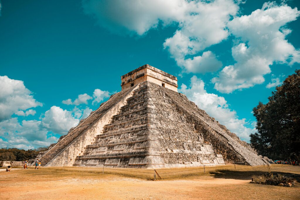
- Postclassic Period (c. 900 – 1500 CE): Following the decline of many southern cities, northern centers like Chichen Itza gained prominence. This era continued until the Spanish conquest in the 16th century.
Maya society was hierarchical, with a ruling class overseeing various aspects of life, including religion, politics, and commerce. They are celebrated for their sophisticated writing system, the most advanced in pre-Columbian Americas, as well as their art, architecture, and scientific knowledge.
The Maya constructed impressive pyramids, palaces, and ceremonial centers, often aligned with astronomical events. Their agricultural practices included terrace farming and irrigation systems, enabling them to sustain large populations. Recent LiDAR technology has unveiled extensive modifications to the landscape, such as terraces, irrigation channels, reservoirs, fortifications, and causeways, revealing “an astonishing amount of land modification done by the Maya over their entire landscape on a scale previously unimaginable.”
The Maya civilization’s contributions continue to influence contemporary society, particularly in areas like calendar systems and architectural design. Their descendants still inhabit Central America, preserving many aspects of their rich cultural heritage.
How LiDAR Works: Revolutionizing Archaeology
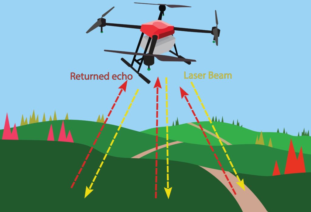
LiDAR, an acronym for Light Detection and Ranging, is a remote sensing technology that employs laser pulses to generate precise, three-dimensional maps of the Earth’s surface. By emitting laser beams from an aerial platform—such as an airplane or drone—LiDAR measures the time it takes for each pulse to bounce back after hitting the ground or other objects. This data is then used to construct detailed topographical models, effectively “peeling back” dense vegetation to reveal the underlying terrain.
In the realm of archaeology, LiDAR has been transformative, especially in regions where thick forest canopies obscure ancient structures. Traditional ground-based surveys are often labor-intensive and limited in scope, but LiDAR allows researchers to survey extensive areas rapidly and with remarkable accuracy. As archaeologist Marcello Canuto notes, “LiDAR has been revolutionary for archaeology in this area, especially if it’s covered in tropical forest where visibility is limited.”
The application of LiDAR in Mesoamerican studies has led to groundbreaking discoveries. For instance, a LiDAR survey in northern Guatemala unveiled a vast network of ancient Maya structures previously hidden beneath the jungle canopy. This included more than 60,000 houses, palaces, elevated highways, and other human-made features, revealing a sprawling pre-Columbian civilization that was far more complex and interconnected than most Maya specialists had supposed.
Similarly, in Mexico’s Yucatán Peninsula, LiDAR technology uncovered the ancient city of Valeriana, revealing over 6,500 pre-Hispanic structures, including pyramids and causeways, that had been concealed by dense vegetation. This discovery highlighted the density and variability of Maya settlements, challenging previous assumptions about the civilization’s urban and rural distribution.
By enabling archaeologists to visualize and analyze landscapes on a macro scale, LiDAR not only facilitates the discovery of hidden sites but also enhances our understanding of ancient civilizations’ spatial organization and environmental adaptations. As Canuto emphasizes, “We can now see the entire landscape of the Maya region,” allowing for a more comprehensive understanding of how these societies functioned and interacted with their environment.
Major Discoveries: Mapping the Hidden Cities
The application of LiDAR technology has unveiled a vast network of ancient Maya structures previously concealed beneath dense tropical canopies. In Guatemala’s Petén region, over 60,000 previously unknown structures—including houses, palaces, elevated highways, and defensive fortifications—have been identified. This revelation suggests a civilization far more complex and interconnected than previously understood.
In northern Guatemala’s Mirador-Calakmul Karst Basin, LiDAR surveys have revealed approximately 1,000 ancient Maya settlements. These sites are interconnected by an extensive network of causeways, indicating a high degree of political and economic integration.
Similarly, in Mexico’s Yucatán Peninsula, the ancient city of Valeriana was discovered using LiDAR technology. This site encompasses over 6,500 pre-Hispanic structures, including pyramids and causeways, highlighting the density and variability of Maya settlements in the region.
These findings challenge previous assumptions about the Maya civilization, revealing a level of societal complexity and environmental adaptation that was previously underestimated. As archaeologist Francisco Estrada-Belli remarked, “LiDAR is revolutionizing archaeology the way the Hubble Space Telescope revolutionized astronomy.”

Rewriting Maya History
The advent of LiDAR technology has profoundly transformed our understanding of the ancient Maya civilization, challenging long-held assumptions and revealing a society of remarkable complexity and sophistication. Traditional archaeological methods often portrayed the Maya lowlands as sparsely populated regions with isolated city-states. However, LiDAR surveys have unveiled extensive urban and rural networks, indicating a densely populated and interconnected civilization. As noted by National Geographic, “Dozens of lidar surveys…have upended long-established impressions of a civilization that thrived in one of Earth’s least hospitable regions.”
These revelations have prompted scholars to reevaluate the societal and political structures of the Maya. The discovery of vast causeways, agricultural terraces, and irrigation systems suggests a centralized planning and governance previously unrecognized. Carlos Morales-Aguilar, a researcher involved in LiDAR studies, remarked, “We can now see the entire landscape of the Maya region,” highlighting the unprecedented scale of these findings.
Furthermore, the identification of previously unknown urban centers, such as the city of Valeriana in Mexico’s Yucatán Peninsula, underscores the extensive reach and diversity of Maya settlements. This city, revealed through LiDAR analysis, encompasses over 6,500 pre-Hispanic structures, including pyramids and causeways, challenging previous notions of Maya urbanization.
Collectively, these discoveries necessitate a comprehensive reassessment of Maya history, acknowledging the civilization’s advanced engineering, agricultural innovation, and complex societal organization. As archaeologist Francisco Estrada-Belli aptly stated, “LiDAR is revolutionizing archaeology the way the Hubble Space Telescope revolutionized astronomy.”
The Future of LiDAR in Archaeology
LiDAR technology has revolutionized archaeological research, enabling the detection and analysis of sites obscured by dense vegetation or challenging terrains. Its ability to produce high-resolution, three-dimensional maps of the Earth’s surface has unveiled previously hidden structures and landscapes, offering profound insights into ancient civilizations.
The integration of LiDAR with unmanned aerial vehicles (UAVs), commonly known as drones, has further enhanced its applicability. This combination allows for rapid and extensive surveying of archaeological sites, significantly reducing the time and labor traditionally required. As noted in a study on LiDAR drones in archaeological excavations, “This method ensures comprehensive coverage of archaeological sites in a fraction of the time traditional surveys would take.”
Moreover, advancements in machine learning and artificial intelligence are augmenting the processing and interpretation of LiDAR data. Automated algorithms can now assist in identifying and classifying archaeological features within LiDAR datasets, increasing efficiency and accuracy. A recent study highlights that “advances in machine learning and VR/AR have further resulted in improved classification and visualization.”
However, the application of LiDAR in archaeology is not without challenges. The technology can produce vast amounts of data, necessitating substantial storage and processing capabilities. Additionally, while LiDAR can penetrate vegetation to reveal ground surfaces, its effectiveness can be limited by factors such as dense canopy cover and terrain ruggedness. A case study evaluating LiDAR’s effectiveness over known archaeological sites noted that “vegetation cover, particularly during leaf-on periods, can interfere with the ability of LiDAR to penetrate to the surface and can therefore impact its accuracy.”
Illuminating the Maya Legacy
LiDAR technology has opened an extraordinary window into the past, unveiling the hidden grandeur of the ancient Maya civilization. From sprawling cities and intricate networks of causeways to advanced agricultural systems, these discoveries challenge long-held assumptions about the scale and complexity of this remarkable society. As Francisco Estrada-Belli aptly noted, “LiDAR is revolutionizing archaeology the way the Hubble Space Telescope revolutionized astronomy,” and this revolution is far from over.
While we marvel at the ingenuity of the Maya and their ability to thrive in challenging environments, these findings also remind us of the fragility of civilizations and their dependence on sustainable interactions with nature. LiDAR’s continued use in archaeology promises to unearth countless more secrets, not only from the Maya but also from other ancient cultures obscured by the passage of time.
By revealing the intricate tapestry of human history, LiDAR not only enriches our understanding of the past but also inspires us to reflect on our own place within the evolving narrative of human civilization. The story of the Maya is no longer buried; it is a vivid reminder of resilience, innovation, and the enduring quest for knowledge.


