Environment
Satellite Images Show A Staggering Amount Of Water Loss At Lake Mead Since 2000
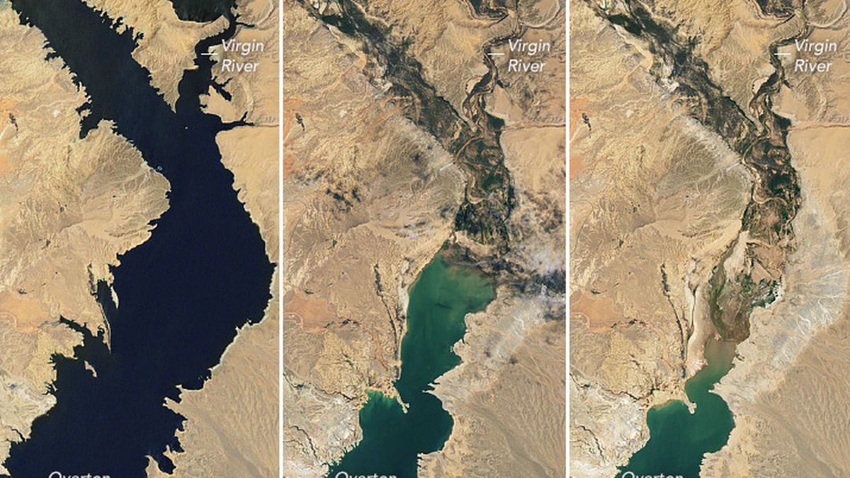
NASA has published new satellite photographs that illustrate the significant loss of water in Lake Mead since 2000.

NASA has published new satellite photographs that illustrate the significant loss of water in Lake Mead since 2000.
NASA said in the announcement that the photographs released show that the water levels in Lake Mead are presently at their lowest point since April 1937, which was the month when the reservoir was just beginning to be filled for the first time.
Lake Mead has only 27 percent of its total capacity as of the 18th of July. In addition, NASA reported that the water height at the Hoover Dam was 1,041.30 feet above sea level as of July 18; the water elevation at the end of July 2000 was 1,199.97 feet.
“Lake levels at the dam should stay above 1000 feet to continue operating hydropower turbines at normal levels,” NASA said.
Lake Mead is the source of drinking water for about 25 million people in the states of Arizona, Nevada, California, and Mexico.
Even in the gap of one year that separates 2021 and 2022, the photographs that were taken of Lake Mead by the NASA Earth Observatory reveal that it seems to have less and less water in it.
These photographs were taken in the years 2000, 2021, and 2022. The view from 2000 depicts large portions of Lake Mead to be filled with water, however the image from 2022 reveals that just one area of the lake, which is referred to as Overton Arm, is full.
The fact that individuals who have depended on the water from Lake Mead for decades would be adversely affected by this loss highlights the gravity of the situation. According to the U.S. Drought monitor, 74 percent of nine Western states are presently reporting some degree of drought, and 35 percent are suffering severe levels of drought.
The release of these photos also comes at a time when states across the West are experiencing significant levels of drought.
“The largest reservoir in the United States supplies water to millions of people across seven states, tribal lands, and northern Mexico,” NASA Earth Observatory’s news release reads. “It now also provides a stark illustration of climate change and a long-term drought that may be the worst in the U.S. West in 12 centuries.”
The waters of Lake Mead have been quickly draining in recent months, and as a result, human remains, abandoned communities, a downed B-29 Superfortress, and other things have been exposed.
In May, Travis Heggie, a former officer with the National Park Service who has examined the fatalities that have occurred at Lake Mead Recreation Area, spoke with USA TODAY and said that, “This is just the tip of the iceberg.”
The Hoover Dam, which was responsible for the formation of Lake Mead, is seeing a major decline in water height.
In July of 2000, the water level at Hoover Dam was about 1,200 feet above sea level, as shown by statistics provided by the United States Bureau of Reclamation. As of the 18th of this month, it has decreased to around 1,040 feet.
The water level of Lake Powell, which is located in northern Arizona and southern Utah and is located above Lake Mead, is likewise dangerously low. According to NASA, Lake Powell is now at 27 percent of its capacity, which is the same as Lake Mead.
For those living in the Southwest United States, the situation is dire.
Typos, corrections and/or news tips? Email us at Contact@TheMindUnleashed.com
