Environment
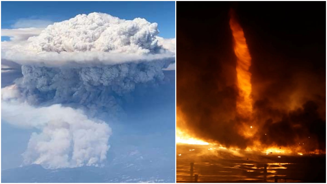
West Coast wildfires are creating fire clouds and “firenadoes” on a staggering scale, scientists warn
Experts have warned that the impacts of the fires are unprecedented.

As wildfires continue to consume massive swathes of California and the Pacific Northwest states of Oregon and Washington, experts have warned that the impacts of the fires are unprecedented and provide a sharp warning of things to come.
In California, no less than 3.1 million acres – almost 5,000 square miles – have burned, an alarming start to a record-shattering fire season that is likely to continue for at least another four months.
And as cities across the West Coast have seen their skies turned an apocalyptic orange and red by the over 85 major fires burning throughout the region, parts of Oregon are experiencing a major drop in air quality that has gone far beyond merely “hazardous,” with implications that remain unknown, reports Grist.
While EPA Air Quality Index (AQI) measures max out at 500, the region surrounding Eugene, Oregon, shot deep into the 700 range, meaning that the ash and fine particulate matter from the wildfires is likely flooding the lungs and even bloodstreams of local residents, fueling the risk of major respiratory and cardiovascular problems.
The suffocating plumes of smoke from the West Coast have even extended over a thousand miles across the North Atlantic ocean to parts of the UK, reports the Daily Mail. On Friday, fire smoke produced hazy skies and an orange glow over parts of Ireland and Britain, with atmospheric physicist Hugo Ricketts noting that “there was definitely a slight red tint to the sun over Manchester.”
The brutal inferno that is expanding across the west coast has seen no precedent in scope and scale in modern history, and experts warn that the resulting environmental changes more than doubles the number of extreme wildfire risks.
At least three of the big wildfires over the past three weeks have produced massive fire tornadoes, according to radar data. Meanwhile, tremendous clouds of ash and smoke are generating lightning as wildfire plumes tower as high up as 10 miles, far above the tornadic thunderstorms that ravage states like Oklahoma and Kansas every spring, reports Washington Post.
Just when you think 2020 can't get any worse. Fire tornado somewhere in California.
Posted by KBER 101 on Friday, September 11, 2020
The rapidly expanding fires are spawning a number of (literally) breathtaking “fire clouds” or pyrocumulus clouds, according to images from space collected by National Oceanic and Atmospheric Administration (NOAA) satellites. NASA refers to pyrocumulonimbus as “the fire breathing dragon of clouds,” and notes that they are created when wind, rain, smoke and fire mix over thousands of burning acres. These thunder clouds are triggered by the heat and moisture kicked into the atmosphere by fires, and the fire clouds also send massive amounts of pollutants into the upper atmosphere.
According to Neil Lareau, a professor of atmospheric sciences in the department of physics at the University of Nevada at Reno, the fire clouds are dramatic indicators of extreme fire behavior which themselves can add explosive energy to the ongoing fires, including lethal fire vortices like tornadoes that can incinerate entire communities and create a deadly hazard for firefighters.
Expressing shock about the massive height of the plumes, Lareau said: “Anecdotally, this is the deepest that I’ve seen … It’s about a solid 10,000 feet higher than we’re typically seeing with the highest of these plumes.”
The extreme height of the clouds is a testament to the incredible spread of the fires and resulting release of heat, he added.
“[That], as well as the large burning area, results in the total amount of heat being injected into the atmosphere just being tremendous,” he said.
Looking back at the #CreekFire's big run up to Mammoth Pool: Here is a radar animation of the explosive #pyroCb plume development. This plume was massive, producing multiple pushes above 12 Km. #CAwx #CAfire pic.twitter.com/lHK8Sud7jd
— Neil Lareau (@nplareau) September 9, 2020
The “tremendous plume depth” was made worse by the unsparing heatwave in parts of California, Lareau added. Last weekend, temperatures in the Los Angeles metropolitan region climbed past 121F (49.4C).
“We have a ton of eyes on every fire, looking at every frame, but still, we weren’t seeing these before,” he said, referring to towering fire clouds and numerous fire tornadoes. “And we’re seeing all too much of it right now. It’s rather worrying.”
The terrifying nature of the fires are still extremely foreign and shocking to experts, Lareau noted.
“These are still real outlier events,” he said. “The way I’ve been trying to think about it, if it’s a 1 in 100 event, now we have, what, 7,000 fires on the landscape? The opportunity to experience these extremes of fire weather are off the charts right now.”
Lareau hopes that authorities can begin to take the threat posed by the fires more seriously and begin funding ways to collect vital data behind the science of these wildfires as they become increasingly normalized.
“We really need to advance our understanding about what’s going on with the high-end fires,” he said.
Typos, corrections and/or news tips? Email us at Contact@TheMindUnleashed.com
